Blog

Geostatistical simulations of topography

Short title: DEMsim

Inputs: control.txt - 1020 precise measurements (photogrametric + spot heights); elevations.txt - 2051 points (contours + spot heights); dem10m_tin.asc - 100x150 pixels 30m DEM.
Outputs: simulated DEMs, simulated error surfaces, error assessment statistics.

Purpose and use:

Script to generate and simulate DEMs and assess the error of the height measurements. Prepared for the needs of a research paper ‘Geostatistical modelling of topography using auxiliary maps’. Please consider testing the script before you use it with large datasets.

Programming environment: R / S language
Status of work: Public Domain
Reference: {Geostatistical modelling of topography using auxiliary maps}
Data set name: Zlatibor

Attachment:

zlatibor-1.zip

Generic landforms

Short title: g_landf

Inputs: %1 - table with central values has to have same domain as the class map, %2 standard fuzziness factor (1.5), %3 - domain, %4 - SLOPE, %5 - PLANC and %6 - ACV.
Outputs: membership values (0-1) to each generic landform (stream, ridge, slope, plain, pit and peak)

Purpose and use:

Extracts six generic landforms (stream, ridge, slope, plain, pit and peak).

Programming environment: ILWIS
Status of work: Public Domain
Reference: Geomorphometry: Concepts, Software, Applications

g_landforms.zip

Ebergotzen

Ebergötzen is 10x10 km study area in the vicinity of the city of Göttingen in Central Germany (51°30’03.16’’–51°35’31.45’‘N; 10°00’28.67’’–10°09’15.21’‘E). This area has been extensively surveyed over the years, mainly for the purposes of developing operational digital soil mapping techniques. The dataset has also been frequently used by the SAGA development team and the SciLands GmbH in many of their demonstrations and documents.

Courtesy of Gehrt Ernst, the State Authority for Mining, Energy and Geology, Hannover, Germany.

The final Google Earth layout showing predicted soil texture fractions in topsoil.
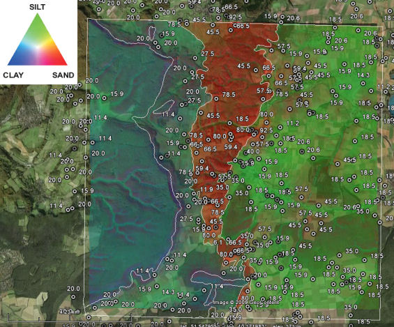
Available layers:

- points.dbf - the point dataset consists of lab measurements four variables are available: SAND, SILT and CLAY (all expressed as % of mass measured for the 0-30 cm layer of soil) and SOILTYPE (type of soil based on the German classification system).
- DEM25.asc - 25 m DEM derived from the topo-maps;
- DEM100.asc - 100 m SRTMDEM;
- landimg.lan - LANDSAT image bands obtained from the http://image2000.jrc.it Corine Land Cover 2000 Project. The image consists of seven bands.
- ZONES.asc - 1:50.000 geological map of Germany.

Grid definition:

ncols: 400
nrows: 400
xllcorner: 3570000
yllcorner: 5708000
cellsize: 25 mproj4:+init=epsg:31467

Lineage: All input raster maps are in ArcInfo *.asc format, and the point data (tables) are in a *.dbf format. All coordinates are in the official German coordinate system, zone 3 (germany3): Transverse Mercator Projection, central meridian is 9°, false easting 3500000, Bessel 1841 ellipsoid with Potsdam datum. The bounding coordinates of the study area are: XMIN=3570000, YMIN=5708000, XMAX=3580000, YMAX=5718000. The input raster maps are available in two grid resolutions: 25 m (fine) and 100 m (coarse). The sand, silt and clay values have been determined by using the so-called_texture by hand_method: a surveyor distinguishes to which of the 32 texture classes a soil samples belongs to, and then estimates the content of fractions. E.g. texture classSt2has 10% clay, 25% silt and 65% sand.

Data owner: State Authority for Mining, Energy and Geology, Hannover, Germany
Reference: Gehrt, E., Buhner, J., (2001) Vom punkt zur flache — probleme des ‘upscaling’ in der bodenkartierung. In: Diskussionsforum Bodenwissenschaften: Vom Bohrstock zum Bildschirm. FH, Osnabruck, pp. 17-34.

Location:Ebergotzen, Germany
51° 34’ 19.2324” N,10° 6’ 28.7964” E
See map:Google Maps


Attachment:

ebergotzen.zip

ebergotzen_input.zip

Digital soil mapping for Baranja Hill

Short title:BARSOIL

Inputs:baranja.txt - 59 field profile observations; 15 raster maps (predictors);
Outputs:Predictions and simulations of SOLUM and GLEY_P.

Purpose and use:

Script to interpolate soil thickness (SOLUM) and occurrence of gley horizon (GLEY_P) using land-surface parameters and mapping units. Prepared for the needs of book ‘Geomorphometry: concepts, software, applications’.

Programming environment:R / S language
Status of work:Public Domain

Reference: Geomorphometry: Concepts, Software, Applications
Data set name: Baranja hill

Attachment:

BARSOIL.zip

Geomorphometry 2009 - Programme

Start: Aug 31 2009 - 09:15End: Sep 2 2009 17:30
Timezone: Europe/Amsterdam

Programme

Monday 31.08.2009

09:15-09:25 Welcoming remarks
09:25-10:15 From ontologies to software (Ross Purves)
  Ralph K. Straumann
Experiences in developing landform ontologies
  T. Hengl, C.H. Grohmman, R.S. Bivand, O. Conrad and A. Lobo
SAGA vs GRASS: a comparative analysis of the two open source desktop GIS for the automated analysis of elevation data
10:15-10:45 Coffee break
10:45-12:30 Methodological developments (Ian Evans)
  John Gallant and Michael Hutchinson
A differential equation for specific catchment area
  Scott Peckham
A New Algorithm for Creating DEMs with Smooth Elevation Profiles
  Thomas Grabs, Jan Seibert, Kelsey Jencso and Brian McGlynn
Calculation of side-separated contributions to stream networks – a new tool to characterize riparian zones
  Justin Washtell, Stephen Carver and Katherine Arrell
A viewshed based classification of landscapes using geomorphometrics
12:30-13:30 Lunch
13:30-14:30 Keynote: Jo Wood
Visualizing Geomorphometry: Lessons from Information Visualization
14:30-15:45 Extracting landscape elements (David Mark)
  Svein Olav Krøgli, Henning Dypvik and Bernd Etzelmüller
Correlation of radial profiles extracted from automatic detected circular features, in the search for impact structure candidates
  Bård Romstad and Bernd Etzelmüller
Structuring the Digital Elevation Model into Landform Elements through Watershed Segmentation of Curvature
  Niels Anders, Harry Seijmonsbergen and Willem Bouten
Multi-scale and object-oriented image analysis of high-res LiDAR data for geomorphological mapping in alpine mountains
15:45-16:15 Coffee break
16:15-18:00 Soil mapping and properties (Tomislav Hengl)
  Rania Bou Kheir, Mogens Greve and Peder Bocher
Use of digital terrain analysis and classification trees for predictive mapping of soil organic carbon in southern Denmark
  Korbinian Kringer, Markus Tusch, Clemens Geitner, Martin Rutzinger, Christoph Wiegand and Gertraud Meißl
Geomorphometric Analyses of LiDAR Digital Terrain Models for Digital Soil Mapping
  Markus Möller, Thomas Koschitzki and Klaus-Jörg Hartmann
Terrain-related revision of existing soil maps
  Brendan Malone
Mapping continuous soil depth functions in the Edgeroi district, NSW, Australia, using terrain attributes and other environmental factors
18:30-19:15 Geomorphometry Society Meeting
19:30-20:30 Welcome drink

   Tuesday 1.09.2009

09:00-10:15 Global-scale geomorphometry (John Gallant)
  Marcello A. V. Gorini
Physiographic classification of the ocean floor: a multi-scale geomorphometric approach
  Peter Guth
Global Survey of Organized Landforms: Recognizing Linear Sand Dunes
  Hannes Isaak Reuter and Andrew Nelson
WorldTerrain- A Contribution to the Global Geomorphometric Atlas
10:15-10:45 Coffee break
10:45-12:30 Multiscale methods (Jo Wood)
  Katherine Arrell and Stephen Carver
Surface roughness scaling trends
  Michael Kalbermatten, Dimitri Van De Ville, Stéphane Joost, Michael Unser and François Golay
Laplace-gradient wavelet pyramid and multiscale tensor structures applied on high resolution DEMs
  Lucian Dragut, Clemens Eisank, Thomas Strasser and Thomas Blaschke
A comparison of methods to incorporate scale in geomorphometry
  Carlos Grohmann, Mike Smith and Claudio Riccomini
Surface roughness of topography: a multi-scale analysis of landform elements in Midland Valley, Scotland
12:30-13:30 Lunch
13:30-14:30 Keynote: Stephan Landtwing
14:30-15:45 Data considerations (Hannes Reuter)
  John Gallant and Arthur Read
Enhancing the SRTM data for Australia
  Rüdiger Köthe and Michael Bock
Preprocessing of Digital Elevation Models - derived from Laser Scanning and Radar Interferometry - for Terrain Analysis in Geosciences
  Haris Papasaika and Emmanuel Baltsavias
Investigation on the Relation of Geomorphological Parameters to DEM Accuracy
15:45-16:15 Coffee break
16:15-18:00 Geomorphological applications (Peter Guth)
  Nicolas Sougnez and Veerle Vanacker
Spatial variability in channel and slope morphology within the Ardennes Massif, and its link with tectonics
  Balázs Székely, Eszter Király, Dávid Karátson and Tamás Bata
A parameterisation attempt of scoria cones of the San Francisco Volcanic Field (Arizona, USA) by conical fitting
  Mathias Ulmer, Peter Molnar and Ross Purves
Influence of DEM and soil property uncertainty on an infinite slope stability model
18:00-late Conference dinner

   Wednesday 2.09.2009

09:00-10:15 Extraterrrestrial geomorphometry (Scott Peckham)
  Tomasz Stepinski and Chaitanya Bagaria
A Two-Stage Classification Approach for Effective Geomorphic Mapping of Planetary Surfaces
  Roderik Koenders, Roderik Lindenbergh and Tanja Zegers
Automated classification of Martian morphology using a Terrain Fingerprinting Method
  Balázs Székely and Tomaž Podobnikar
A method for automated extraction of Martian talus slopes – case studies of Nanedi Valles and West Candor Chasma, Mars
10:15-10:45 Coffee break
10:45-12:30 Extracting hydrological networks (Robert MacMillan)
  Paolo Tarolli, Giancarlo Dalla Fontana, Giovanni Moretti and Stefano Orlandini
Cell Size Dependence of Threshold Conditions for the Delineation of Drainage Networks from Gridded Elevation Data
  Nathalie Thommeret, Jean-Stéphane Bailly and Christian Puech
Robust extraction of thalwegs networks from DTMs for topological characterisation: a case study on badlands
  Ashraf Afana and Gabriel Del Barrio
An Adaptive Approach for Channel Network Delineation from Digital Elevation Models
  Laura Poggio and Pierre Soille
Influence of spurious pit removal methods on the position of river networks extracted from SRTM
12:30-13:30 Lunch
13:30-14:30 Keynote: David Mark
From Land Form to Landforms: Bridging the Quantitative-Qualitative Gap in a Multilingual Context
  Extracting hydrological networks (continued)
14:30-15:00 Markus Metz, Helena Mitasova and Russel Harmon
Fast stream extraction from large, radar-based elevation models with variable level of detail
15:00-15:30 Coffee break
15:30-16:45 Glaciological applications (Stephan Gruber)
  Andreas Linsbauer, Frank Paul, Martin Hoelzle, Holger Frey and Wilfried Haeberli
The Swiss Alps Without Glaciers – a GIS-based Modelling Approach for Reconstruction of Glacier Beds
  Ian Evans
Allometric development of glacial cirques: an application of specific geomorphometry
  Regula Frauenfelder, Bernhard Schneider and Bernd Etzelmüller
Morphometric modelling of rockglaciers – A case study from the Alps
16:45 Closing remarks

Latest Posts

ANADEM: A Digital Terrain Model for South America

There is a new paper (open access) describing a Machine Learning-based DTM for South America:

Laipelt L., Andrade B.C., Collischonn W., Teixeira A.A., Paiva R.C.D., Ruhoff A., 2024. ANADEM: A Digital Terrain Model for South America. Remote Sensing 16(13):2321. https://doi.org/10.3390/rs16132321

GRASS GIS 8.4.0RC1 release

The GRASS GIS 8.4.0RC1 release provides more than 515 improvements and fixes with respect to the release 8.3.2.

Check the full announcement at https://github.com/OSGeo/grass/releases/tag/8.4.0RC1.

Please support in testing this release candidate.

Best BiCubic Method to Compute the Planimetric Misregistration between Images with Sub-Pixel Accuracy: Application to Digital Elevation Models

There is a new paper (open access) describing a novel method to estimate sub-pixel planimetric displacements between two DEMs:

Riazanoff, S.; Corseaux, A.; Albinet, C.; Strobl, P.A.; López-Vázquez, C.; Guth, P.L.; Tadono, T. Best BiCubic Method to Compute the Planimetric Misregistration between Images with Sub-Pixel Accuracy: Application to Digital Elevation Models. ISPRS Int. J. Geo-Inf. 13, 96. https://doi.org/10.3390/ijgi13030096