Geomorphometry 2011: Five days of Digital Terrain Analysis (Conference + Workshops)
September 7-11, 2011 (Wednesday to Sunday)
Building Q, ESRI Campus Redlands (map),
California, USA
http://geomorphometry.org/2011
e-mail: 2011@geomorphometry.org
For urgent matters please contact: Melisa Salido (the conference secretary)
This event is sponsored by:

PROGRAM CHAIRS
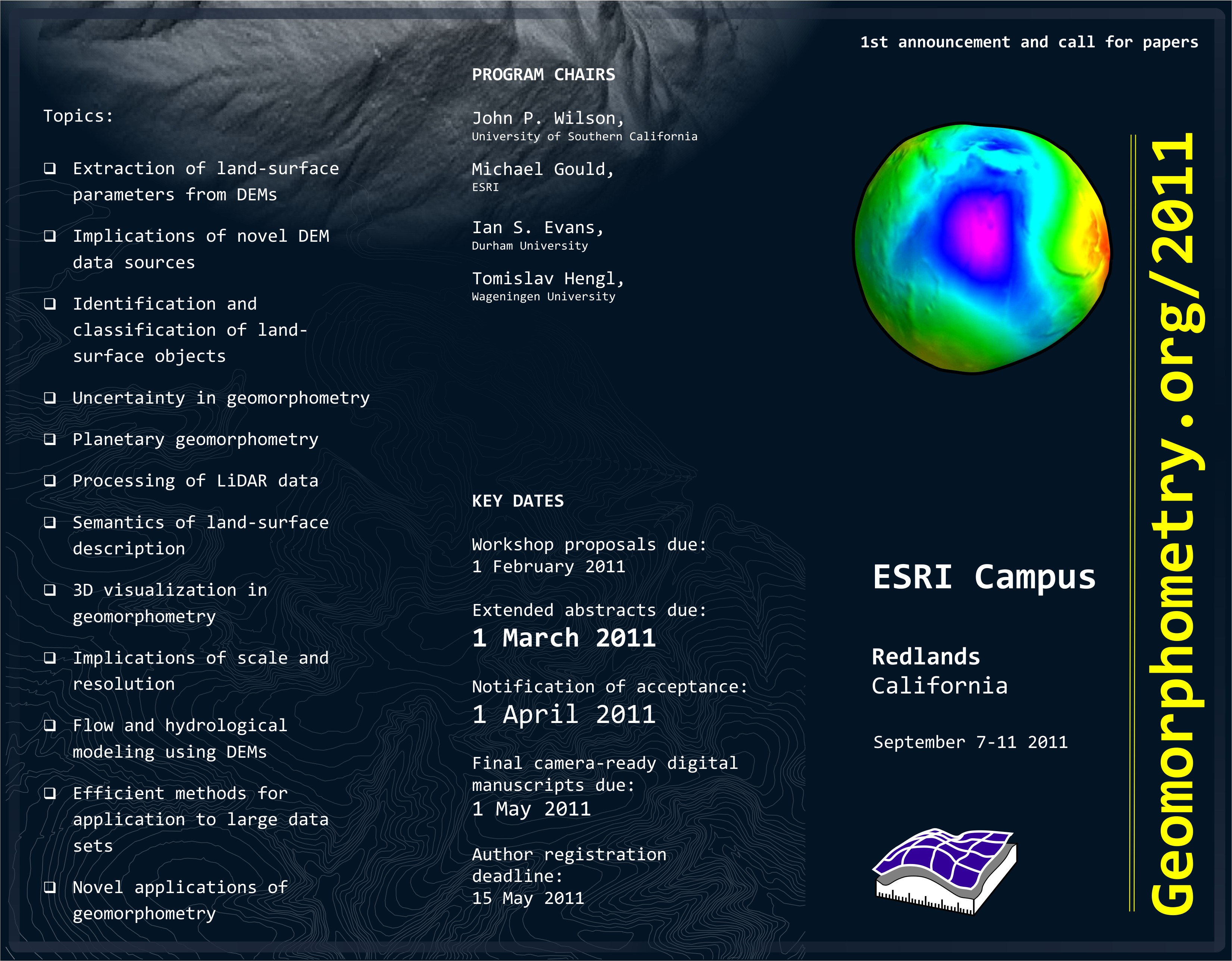
- John P. Wilson, University of Southern California
- Michael Gould, ESRI
- Ian S. Evans, Durham University
- Tomislav Hengl, Wageningen University and Research
KEY DATES
- Workshop proposals due: 1 Februrary 2011
- Extended abstracts due: 1 March 2011
- Late submission deadline: 15 March 2011
- Notification of acceptance: 15 April 2011
- Final camera-ready digital manuscripts due: 15 June 2011
- Early registration deadline: 1st of July
- Late registration deadline: at the conference (+$50 additional fee)
KEYNOTE SPEAKERS
- H Mitasova (7.09 morning)
- J Gallant (8.09 morning)
- Q Zhou (8.09 morning)
- T Oguchi (9.09 morning)
- A-Xing Zhu (9.09 morning)
AIMS AND SCOPE
The aim of Geomorphometry 2011 is to bring together researchers to present and discuss recent developments in the field of quantitative modelling and analysis of elevation data. Geomorphometry is the science of quantitative land-surface analysis and description at diverse spatial scales. It draws upon mathematical, statistical and image-processing techniques and interfaces with many disciplines including hydrology, geology, planetary geomorphology, computational geometry, geomorphology, remote sensing, geographic information science and geography. The conference aims to attract leading researchers in geomorphometry presenting methodological advances in the field and to provide young researchers with an opportunity to present new results.
Redlands is in San Bernardino County and at the eastern end of the S. Californian metropolis, some 100 km east of Los Angeles. It is between ‘The Badlands’ and the San Bernardino Mountains, beyond which is the Mohave Desert.
The Geomorphometry 2011 conference will continue a series initiated by the Terrain Analysis and Digital Terrain Modelling conference hosted by Nanjing Normal University in November 2006 and University of Zurich in 2009.
Possible topics include, but are not limited to:
- Extraction of land-surface parameters from DEMs
- Implications of novel DEM data sources
- Identification and classification of land-surface objects
- Uncertainty in geomorphometry
- Planetary geomorphometry
- Processing of LiDAR data
- Semantics of land-surface description
- 3D visualisation in geomorphometry
- Implications of scale and resolution
- Flow and hydrological modelling using DEMs
- Efficient methods for application to large data sets
- Novel applications of geomorphometry
CONFERENCE PROGRAMME
The conference programme will be based around a single track of papers, all of which will have been subject to review in the form of extended abstracts by members of the scientific committee. The conference programme is available at:
- Conference programme (oral talks; 20 minutes)
The proceedings will be made available both digitally and as printed working materials to attendees at the time of the conference and archived online. A selection of papers will be invited for publication in a special issue of the Transactions in GIS.
WORKSHOPS
Geomorphometry will host two parallel workshops, each with ca. 5-10 attendees after the conference (Saturday day 4):
- (Lucian Dragut & Clemens Eiseink) Discrete analysis of the land-surface: Burning issues and upcoming topics in linking geomorphometry with OBIA
- (Tomislav Hengl & Carlos Grohmann) Automated analysis and visualization of elevation data using open source tools R+OSGeo
 Workshops will take the form of either tutorials in a particular method or technique, or provide the opportunity for detailed discussion of upcoming topics. Workshops will be held in Lewis Hall rooms 102, 103, and/or 104. All rooms have ceiling-mounted 1080p-compatible projectors and screens, and white boards (and white board material cabinets covering 2-3 walls). Rooms 103 and 104 also have SmartBoards and auxiliary 42” 1080p monitors. For more info contact: Mark Kumler.
SUBMISSIONS
Prospective authors are invited to submit extended abstracts of up to 4 pages (ca 2000 words) by 1st of March 2011. Extended abstracts must be original works by the authors, not be currently under review in the same form by another outlet and not submitted elsewhere prior to the notification date.
Authors that have missed the submission deadline for extended abstracts are invited to submit a poster. Up to 30 posters will be considered for a display during the poster blocks. For more info please read the author guidelines.
- Submit a poster for the Conference
REGISTRATION FEES (CONFERENCE)
Registration fees (before 1st of July 2011):
- $200.00 - Student Registration
- $375.00 - Non-Student Registration
- $300.00 - Student Registration w/ Workshop
- $475.00 - Non-Student Registration w/ Workshop
*Click here to register. After you register for the conference and workshops, please add your name to the workshop pages -> sign-up (login to the geomorphometry.org, then go to the workshop of interest and select “sign-up”).
ACCOMMODATION (HOTELS)
We recommend staying at some hotel in the vicinity of the ESRI campus. When you make your reservations, please indicate that you are with the Geomorphometry Conference in order to get the discounted conference rate.
Ayres Hotel (ca. $99 per night)
1015 W. Colton Ave.
Redlands, CA 92374
+1-909-335-9024
Comfort Suites (ca. $80 per night)
1230 W. Colton Ave.
Redlands, CA 92374
+1-909-335-9988
Country Inn & Suites
1650 Industrial Park Avenue
Redlands, CA 92373
+1-909-792-7913
Need help with organizing your trip? Let us know about your arrival/departure times.
SCIENTIFIC COMMITTEE (active reviewers)
- Alexander Brenning, University of Waterloo, Canada
- Lucian Dragut, University of Salzburg, Austria
- Ian Evans, Durham University, UK
- Igor V. Florinsky, Institute of Mathematical Problems of Biology, Russia
- John Gallant, CSIRO, Australia
- Carlos H. Grohmann, University of Sao Paulo, Brazil
- Michael Gould, ESRI, USA
- Steve Kopp, ESRI, USA
- Robert A. MacMillan, ISRIC, the Netherlands
- Helena Mitasova, North Carolina State University, USA
- Brian Lees, University of New South Wales, Australia
- Allan James, University of South Carolina, USA
- Takashi Oguchi, University of Tokyo, Japan
- Scott Peckham, Rivix, USA
- Ross Purves, University of Zurich, Switzerland
- Hannes I. Reuter, ISRIC, the Netherlands
- Nicolas Tate, University of Leicester, UK
- Sebastiano Trevisani, University Iuav of Venice, Italy
- Lynn Usery, USGS Center for Excellence for GIS, USA
- John P. Wilson, University of Southern California, USA
- Jo Wood, City University, UK
- A-Xing Zhu, University of Wisconsin, USA