
- This event has passed.
Geomorphometry 2021
September 13, 2021 @ 9:00 am - September 17, 2021 @ 5:00 pm
The Geomorphometry Society and the Organizing Committee are pleased to announce the sixth Geomorphometry Conference to be held in Perugia, Italy, September 13-17 2021. The event is hosted by the Research Institute for Geo-Hydrological Protection of the Italian National Research Council (CNR IRPI) and the Department of Physics and Geology of the University of Perugia. Details on past editions of the conference are on the geomorphometry.org website.
Official website for “Geomorphometry 2021” event here.
The previous edition of the conference was postponed due the global pandemic. Contributions to the conference were evaluated by the scientific/organizing committee, and authors were notified of acceptance/rejection of their extended abstract; revised abstracts were collected into a volume entitled “Geomorphometry 2020 Conference Proceedings” edited by M. Alvioli, I. Marchesini, L. Melelli & P. Guth and published by CNR Edizioni (Rome, 2020). Individual contributions and the whole volume can be downloaded here.
Authors were invited to extend their contributions to full article length, and submit them for pubblication in a special issue of Transactions in GIS, entitled “Geomorphometry 2020” which wil be published in the third quarter of 2021 (Volume 25); submissions for the 2020 special issue are currently closed.
The 2021 conference will tentatively be held in presence – and will be turned into a remote connection event if the global situation will not improve. We currently aim at a mixed event, so that whoever can/want to travel to Perugia is welcome to do so, but people will still be able to participate in the conference remotely. We are aware of the different time zones issue; we are working on it.
Submissions to the 2021 event are now open; contributions accepted for the 2020 will be retained for the 2021 event; new submissions will be reviewed as usual. Based on actual number of new accepted contributions we will consider publishing a new conference proceedings and/or a new journal publication.
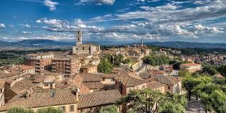
Perugia, Italy – Venue of Geomorphometry 2021
Geomorphometry is the science of quantitative land surface analysis. It gathers various mathematical, statistical and image processing techniques that can be used to quantify morphological, hydrological, ecological and other aspects of a land surface. Common synonyms for geomorphometry are geomorphological analysis, terrain morphometry or terrain analysis and land surface analysis.
Scientific Program
Topics
- Use of Digital Elevation, Terrain and Surface Models
- High resolution data collected with LiDAR, photogrammetry and satellite imagery
- Automated surface analysis with machine learning and new algorithms
- Measurements and simulations Earth surface changes
- 3D and 4D dynamics of Earth surface
- Morphometric techniques for climate change studies
- Modeling extreme processes and natural hazards on the Earth surface
- Marine Geomorphometry and bathymetry data
- Geomorphometry for urban areas and cultural heritage
- Planetary morphometry
- Professional and industrial applications of Geomorphometry
Timetable (Time is in Italian local time: CEST (Central European Summer Time) UTC/GMT +2 hours)
SEPTEMBER 13: USE OF DIGITAL ELEVATION, TERRAIN AND SURFACE MODELS
10.00: Opening connections
10.15: Conference opening
| 10.30-10.45 | Jozef Minár, Marián Jenčo and Ian S. Evans
What does land surface curvature really mean? |
Short | VID | |
| 10.45-11.00 | Cheng-Zhi Qin, Peng Liang and A-Xing Zhu
Two case-based (published as full paper in Transactions in GIS) |
Short | VID | |
| 11.00-11.15 | Fran Domazetović, Ante Šiljeg and Ivan Marić
Guidelines for optimization of terrestrial laser scanning surveys over gully erosion affected areas |
Short | VID | |
| 11.15-11.30 | Alexey Victorov, Olga Trapeznikova and Timofey Orlov
Probabilistic behavior modeling of morphometric parameters for thermokarst plains with fluvial erosion in Cryolithozone |
Short | VID |
11.30-11.45: Break time
| 11.45-12.15 | Keynote talk: Marco Cavalli, Stefano Crema and Lorenzo Marchi
Sediment connectivity assessment through a geomorphometric approach: review of recent applications |
Short | VID | |
| 12.15-12.30 | John Gallant
The surface stream function: representing flow topology with numbers |
Short | VID | |
| 12.30-12.45 | John Gallant
The D8 implementation of the surface stream function |
Short | VID |
12.45-13.00: Discussion and Conclusion
13.00-14.00 Lunch time
| 14.00-14.15 | Marina Metes, Kristina Hopkins, Labeeb Ahmed, Sam Lamont, Peter Claggett and Greg Noe
Mapping stream and |
Short | VID | |
| 14.15-14.30 | Adeyemi Olusola
Lithology and channel network initiation and orientation: a case study of upper Ogun River Basin, Soyhwestern Nigeria |
Short | VID | |
| 14.30-14.45 | Priyank Patel, Sayoni Mondal and Rajarshi Dasgupta
Morphometric and channel (published as full paper in Transactions in GIS) |
Short | VID | |
| 14.45-15.00 | Francesco Bucci, Michele Santangelo, Francesco Mirabella, Andrea Mazzoni and Mauro Cardinali
Drainage inversion revealed by geomorphometric analysis of fluvial terraces |
Short | VID |
15.00-15.15: Break time
| 15.15-15.30 | Mihai Niculita
Burial mound detection using geomorphometry and statistical methods: pixels versus objects |
Short | VID | |
| 15.30-15.45 | Richard Feciskanin and Jozef Minár
An optimization of triangular network and its use in DEM generalization for the land surface segmentation (published as full paper in Transactions in GIS) |
Short | VID | |
| 15.45-16.00 | Vincent Lecours and Michael Espriella
Can multiscale roughness help computer-assisted identification of coastal habitats in Florida? |
Short | VID | |
| 16.00-16.15 | Charles Holderman, Steve Kopp and Nawajish Noman
A New Analytic Framework and Notebook for Terrain Analysis |
Short | VID |
16.30-16.45: Discussion and Conclusion
SEPTEMBER 14 DYNAMICS OF EARTH SURFACE: AUTOMATED SURFACE ANALYSIS AND MODELIZATION
10.00: Opening connections
10.15: Conference opening
| 10.30-10.45 | Peter Guth
Using high-resolution lidar point clouds to evaluate 1-3 arc second global digital elevation models |
Short | VID | |
| 10.45-11.00 | Tera Geoffroy and Peter Guth
Using high-resolution ICESat-2 point clouds to evaluate 1-3 arc second global digital elevation models (published as full paper in Transactions in GIS) |
Short | VID | |
| 11.00-11.15 | Daniele Pinton, Alberto Canestrellli, Christine Angelini, Benjamin Wilkinson, Peter Ifju and Andrew Ortega
Estimating the spatial (published as full paper in Earth Surface Processes and Landforms) |
Short | VID | |
| 11.15-11.30 | Guanghui Hu, Liyang Xiong and Guoan Tang
Mathematical vector framework for land surface curvature calculation from triangulated irregular network |
Short | VID |
11.30-11.45: Break time
11:45-11:50: Announcement of Lifetime Achievement Award — PDF — VID
| 11.50-12.20 | Keynote talk: Michael Hutchinson – Reflections on adding the Z dimension to earth system analysis | Short
Paper |
VID | |
| 12.20-12.35 | Sebastiano Trevisani
Geomorphometric features selection based on intrinsic dimension estimation |
Short | VID | |
| 12.35-12.50 | Kacper Jancewicz, Piotr Migoń, Wioleta Porębna and Milena Różycka
High-resolution |
Short | VID |
12.50-13.00: Discussion and Conclusion
13.00-14.00: Lunch time
| 14.00-14.15 | Tomislav Hengl and Leandro Parente
Continental-scale Digital Terrain Model for EU based on Ensemble Machine Learning |
Short
Paper |
VID | |
| 14.15-14.30 | Gaurav Sinha and Samantha Arundel
Automated Extraction of Areal Extents For GNIS Summit Features Using the Eminence-Core Method |
Short | VID | |
| 14.30-14.45 | Olga Ishalina, Dmitrii Bliakharskii and Igor Florinsky
Detection of crevasses (published as full paper in Transactions in GIS) |
Short | VID | |
| 14.45-15.00 | Carlos Grohmann, Guilherme Garcia, Alynne Affonso and Rafael Albuquerque
Coastal dune modelling from airborne LiDAR, terrestrial LiDAR and Structure from Motion–Multi View Stereo (published as full paper in Computers & Geosciences) |
Short | VID |
15.00-15.15: Break time
| 15.15-15.30 | Bartłomiej Szypuła
DEM from topographic maps – as good as DEM from LiDAR? |
Short | VID | |
| 15.30-15.45 | Anna Dedkova, Igor Florinsky and Nikolay Djuzhev
Analysis of topography of silicon wafers and wafer-based structures by geomorphometric modeling |
Short | VID | |
| 15.45-16.00 | Peter L. Guth and Morgan E. Kane
Evaluation of slopes calculated from TanDEM-X digital elevation models at 3 spatial resolutions |
Short | VID | |
| 16.00-16.15 | Ivan Marić, Ante Šiljeg, Fran Domazetović and Neven Cukrov
A framework for using handheld 3D surface scanners in quantifying the volumetric tufa growth |
Short | VID | |
| 16.15-16.30 | Ante Šiljeg, Vlatko Roland, Lovre Panđa, Ivan Marić, Fran Domazetović, Silvija Šiljeg and Rina Milošević
Development of the new methodological framework for multiscale modeling of urban pluvial flooding |
Short | VID |
16.30-16.45: Discussion and conclusion
SEPTEMBER 15 MODELING GEOMORPHOLOGICAL PROCESSES
10.00: Opening connections
10.15: Conference opening
| 10.30-10.45 | Andrei Dornik, Lucian Drăguț, Marinela Adriana Chețan, Takashi Oguchi, Yuichi Hayakawa and Mihai Micu
Towards a consistent set of land-surface variables for landslide modelling |
Short | VID | |
| 10.45-11.00 | Mihai Niculita
Landslide topographic signature prediction using segmentation of roughness and Random Forest |
Short | VID | |
| 11.00-11.15 | Stefan Steger
The role of pre-landslide morphology in statistical modelling of landslide-prone areas (published as full paper in Geomorphology) |
Short | VID | |
| 11.15-11.30 | Shui Yamaguchi and Mio Kasai
Incorporating ground cracks in the estimation of post-seismic landslide susceptibility |
Short | VID |
11.30-11.45: Break time
| 11.45-12.15 | Keynote talk: Igor Florinsky, Sergey Filippov and Alexander Govorov
3D marine geomorphometry for the Arctic Ocean |
Short | VID | |
| 12.15-12.30 | Margaret Dolan, Lilja Bjarnadóttir, Terje Thorsnes, Markus Diesing and Shyam Chand
Geomorphometry in the deep Norwegian Sea |
Short | VID | |
| 12.30-12.45 | Queralt Guerrero, Ariadna Salabarnada, Amadeu Deu and Marcelo Devincenzi
Marine geophysical investigations for offshore wind farms and submarine interconnection cables |
Short | VID |
12.45-13.30: Meeting of the International Society for Geomorphometry. Everybody is welcome to attend. External link to the meeting (Google Meet) will be posted here
13.00-14.00: Lunch time
| 14.00-14.15 | Ivica Milevski, Marjan Temovski, Balazs Madarasz, Zoltan Kern and Zsofia Ruszkiczay-Rudiger
Geomorphometry of the cirques of Shar Mountain |
Short | VID | |
| 14.15-14.30 | Ivica Milevski, Bojana Aleksova and Sonja Lepitkova
Geomorphometric characteristics of the high mountains in North Macedonia |
Short | VID | |
| 14.30-14.45 | Ian Sylvester Evans, Nicholas J. Cox, Mihai Niculita and David Milledge
Hypsoclinometric evidence of the degree of modification of mountains by glacial erosion |
Short | VID | |
| 14.45-15.00 | Simone Tarquini, Massimiliano Favalli, Melissa Pfeffer, Mattia De’ Michieli Vitturi, Sara Barsotti and Gro Pedersen
Assessing the impact of lava flows during the unrest of Svartsengi volcano in the Reykjaness peninsula, Iceland |
Short | VID |
15.00-15.15: Break time
| 15.15-15.30 | Giuseppe Amatulli, Tushar Sethi, Longzhu Shen, JaimeRicardo, Garcia-Márquez, Jens Kiesel and Sami Domisch
A new and extendable global watershed and stream network delineation using GRASS-GIS |
Short | VID | |
| 15.30-15.45 | Atrayee Biswas, Sunando Bandyopadhyay and Abhijit Chakraborty
Characterizing Gully Morphology using Structure-from-Motion (SfM) in Garhbeta Badlands, West Bengal, India |
Short | VID | |
| 15.45-16.00 | Badal Pokharel, Massimiliano Alvioli and Samsung Lim
Relevance of |
Short | VID | |
| 16.00-16.15 | Massimiliano Alvioli, Michele Santangelo, Federica Fiorucci, Mauro Cardinali, Ivan Marchesini, Paola Reichenbach and Mauro Rossi
A data-driven method for assessing the probability for terrain grid cells of initiating rockfalls on a large area (published as full paper in Engineering Geology) |
Short | VID | |
| 16.15-16.30 | Nada Ait Ayad, Adnane Habib, Khalid Elkhalidi, Abdeloihab Choukri and Abdelmounim Charif
Geomorphometric Analysis for Mapping Platforms of the Mazagan Corridor, Morocco |
Short | VID |
16:30 – 16:45: Announcement of best paper & best student paper awards recipients:
| Best student paper award | Daniele Pinton | Daniele Pinton, Alberto Canestrellli, Christine Angelini, Benjamin Wilkinson, Peter Ifju and Andrew Ortega
Estimating the spatial (published as full paper in Earth Surface Processes and Landforms) |
Short Paper | VID | |
| Best paper award #1 | Michael Hutchinson | Michael Hutchinson – Reflections on adding the Z dimension to earth system analysis | Short
Paper |
VID | |
| Best paper award #2 | Federica fiorucci | Massimiliano Alvioli, Michele Santangelo, Federica Fiorucci, Mauro Cardinali, Ivan Marchesini, Paola Reichenbach and Mauro Rossi
A data-driven method for assessing the probability for terrain grid cells of initiating rockfalls on a large area (published as full paper in Engineering Geology)
|
Short
|
VID |
16.30 – 17.00: Discussion and closing remarks