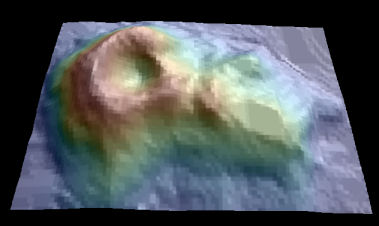
Maunga Whau (Mt Eden) is one of about 50 volcanos in the Auckland volcanic field. This data set gives topographic information for Maunga Whau on a 10 m by 10 m grid. A matrix with 87 rows and 61 columns, rows corresponding to grid lines running east to west and columns to grid lines running south to north.
Available layers:
– volcano_maungawhau.asc — the 10 m DEM digitized from the topo map;
Grid definition:
ncols: 61
nrows: 87
xllcorner: 2667400
yllcorner: 6478700
cellsize: 10 m
proj4: +init=epsg:27200
Lineage:
Digitized from a topographic map by Ross Ihaka. These data should not be regarded as accurate.
> data(volcano)
> library(spatstat)
> LLC <- data.frame(E=174.761345, N=-36.879784)
> coordinates(LLC) <- ~E+N
> proj4string(LLC) <- CRS("+proj=longlat +datum=WGS84")
> LLC.NZGD49 <- spTransform(LLC, CRS("+init=epsg:27200"))
> volcano.r <- as.im(list(x=seq(from=2667405, length.out=61, by=10),
+     y=seq(from=6478705, length.out=87, by=10),
+     z=t(volcano)[61:1,]))
> volcano.sp <- as(volcano.r, "SpatialGridDataFrame")
> proj4string(volcano.sp) <- CRS("+init=epsg:27200")
# str(volcano.sp)
# spplot(volcano.sp, at=seq(min(volcano.sp$v), max(volcano.sp$v),5),
+    col.regions=topo.colors(45))
> write.asciigrid(volcano.sp, "volcano_maungawhau.asc", na.value=-1)
Data owner: LINZ
Location: Volcano Maungawhau Auckland, New Zealand
36° 50′ 50.586″ S, 174° 45′ 56.646″ E
Attachment:
![]()