Ebergötzen is 10×10 km study area in the vicinity of the city of Göttingen in Central Germany (51°30’03.16”–51°35’31.45”N; 10°00’28.67”–10°09’15.21”E). This area has been extensively surveyed over the years, mainly for the purposes of developing operational digital soil mapping techniques. The dataset has also been frequently used by the SAGA development team and the SciLands GmbH in many of their demonstrations and documents.
Courtesy of Gehrt Ernst, the State Authority for Mining, Energy and Geology, Hannover, Germany.
Available layers:
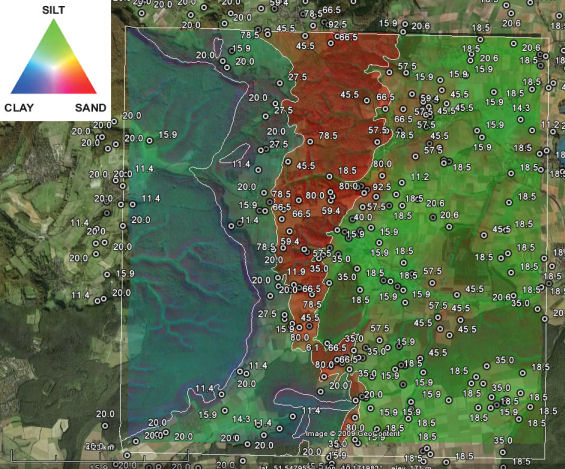
– points.dbf — — the point dataset consists of lab measurements four variables are available: SAND, SILT and CLAY (all expressed as % of mass measured for the 0-30 cm layer of soil) and SOILTYPE (type of soil based on the German classification system).
– DEM25.asc — 25 m DEM derived from the topo-maps;
– DEM100.asc — 100 m SRTM DEM;
– landimg.lan — LANDSAT image bands obtained from the http://image2000.jrc.it & Corine Land Cover 2000 Project. The image consists of seven bands.
– ZONES%.asc — 1:50.000 geological map of Germany.
Grid definition:
ncols: 400
nrows: 400
xllcorner: 3570000
yllcorner: 5708000
cellsize: 25 mproj4: +init=epsg:31467
Lineage:
All input raster maps are in ArcInfo *.asc format, and the point data (tables) are in a *.dbf format. All coordinates are in the official German coordinate system, zone 3 (germany3): Transverse Mercator Projection, central meridian is 9°, false easting 3500000, Bessel 1841 ellipsoid with Potsdam datum. The bounding coordinates of the study area are: XMIN=3570000, YMIN=5708000, XMAX=3580000, YMAX=5718000. The input raster maps are available in two grid resolutions: 25 m (fine) and 100 m (coarse). The sand, silt and clay values have been determined by using the so-called texture by hand method: a surveyor distinguishes to which of the 32 texture classes a soil samples belongs to, and then estimates the content of fractions. E.g. texture class St2 has 10% clay, 25% silt and 65% sand.
Data owner: State Authority for Mining, Energy and Geology, Hannover, Germany
Reference: Vom Punkt zur Flache – Probleme des “upscaling” in der Bodenkartierung
Location: Ebergotzen, Germany
51° 34′ 19.2324″ N, 10° 6′ 28.7964″ E
See map: Google Maps
Attachment:
![]()