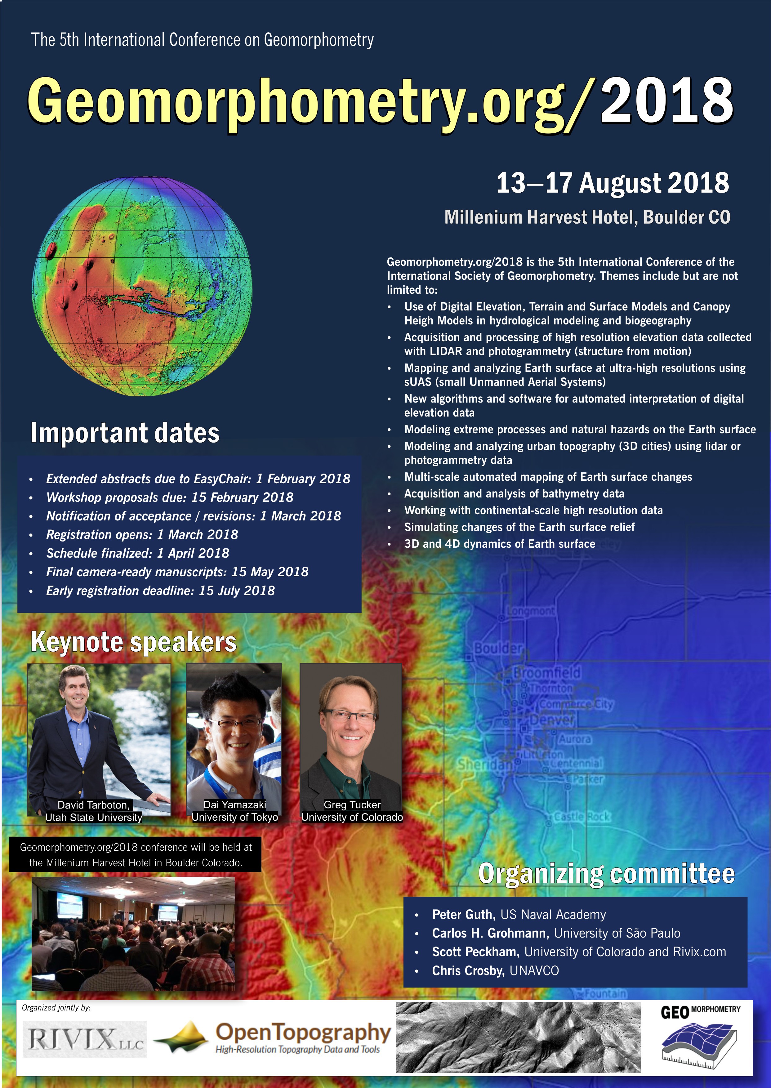
Geomorphometry 2018: Conference and Workshops
Start: Aug 13 2018 - 09:00 End: Aug 17 2018 - 21:44 Timezone: America/Denver
SUBMISSIONS
Submissions are now closed.
Submission instructions:
- EasyChair system opens for submissions: 1 December 2017.
- Download the abstract template.
- Prepare a 2-4 pages abstract closely following the instructions.
- Submit your abstract by 1 February 2018 1 March 2018 15 March 2018 the latest via the EasyChair system.
- Do not submit poorly prepared, incomplete and/or already used materials. Your paper will be reviewed by three members of the scientific committee.
- After the review process is completed, you will be invited to submit the final camera-ready digital manuscripts.
KEY DATES
- EasyChair system opens for submissions: 1 December 2017
- Extended 4 page abstracts due to EasyChair: 1 February 2018 1 March 2018 15 March 2018
- Workshop proposals due: 15 March 2018
- Notification of acceptance and required revisions: 1 April 2018
- Registration opens: 1 April 2018
- Schedule finalized: 1 April 2018
- Final camera-ready digital manuscripts due: 15 May 2018
- Early registration deadline: 15 June 2018
- Conference: August 13-17 2018
PROGRAMME
Programme is here
WORKSHOPS
Workshops are available here
SCIENTIFIC COMMITTEE
- Alexander Brenning, Friedrich-Schiller-Universität Jena, Germany
- Lucian Dragut, West University of Timisoara, Romania
- Ian Evans, Durham University, UK
- John Gallant, CSIRO, Canberra, Australia
- Carlos H. Grohmann, University of Sao Paulo, Brazil
- Peter Guth, US Naval Academy, USA
- Tomislav Hengl, Envirometix Ltd,Wageningen, the Netherlands
- Jaroslav Hofierka, University of Presov, Slovakia
- Steve Kopp, ESRI, USA
- John Lindsay, University of Guelph, Canada
- Robert A. MacMillan, LandMapper Ltd, Canada
- Scott Peckham, Rivix / University of Colorado, USA
- Ross Purves, University of Zurich, Switzerland
- Hannes Reuter, Gisxperts, Trier, Germany
- John P. Wilson, University of Southern California, USA
- Qiming Zhou, Hong Kong Baptist University, Hong Kong
- A-Xing Zhu, Nanjing Normal University, China
Organizing Committee:
- Chris Crosby, UNAVCO
- Carlos H. Grohmann, University of Sao Paulo, Brazil
- Peter Guth, US Naval Academy, USA
- Scott Peckham, Rivix / University of Colorado, USA
Venue:
Millenium Harvest Hotel
1345 28th Street
Boulder
United States See map: Google Maps